Evolution de la population âgée de 65 ans et plus entre 2000 et 2016

Filtres actifs Tout effacer

Aucun filtre actif.

Jeu de données affiché :

enregistrement
Filtres
x

enregistrement

Filtres

Description

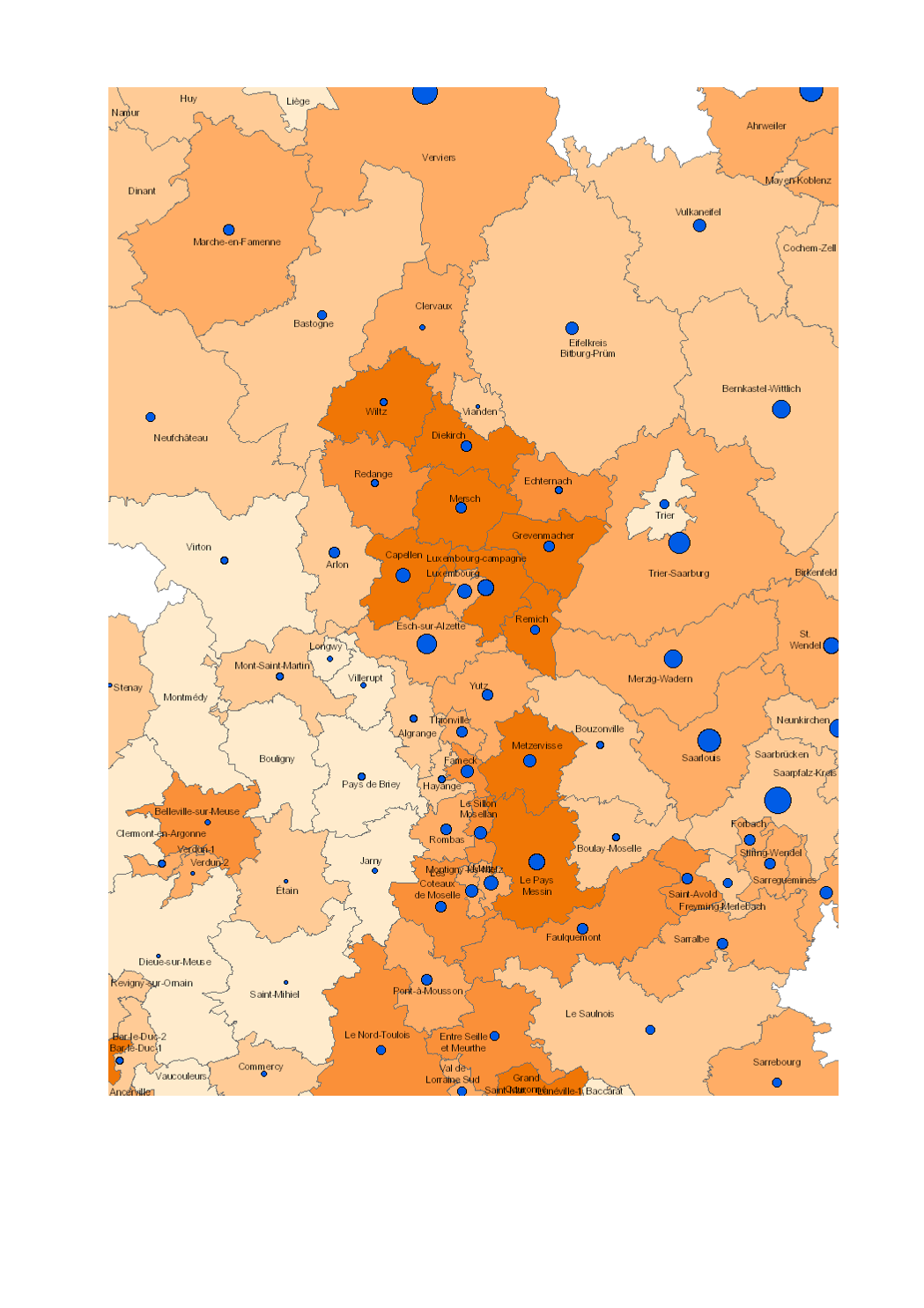
  • Augmentation du nombre de personnes âgées de 65 ans et plus (2000-2016) - Evolution de la population âgée de 65 ans et plus entre 2000 et 2016 (Lorraine: 1999-2014, Luxembourg: 2001-2017)

  • Unités territoriales: arrondissements (Wallonie), cantons (Lorraine, Luxembourg), Kreise (Saarland, Rheinland-Pfalz)

  • Sources des données statistiques: INSEE Lorraine, Statistisches Landesamt Rheinland-Pfalz, Statistisches Amt Saarland, STATEC, IWEPS. Calculs: LISER 2018

  • Sources des données géographiques: ACT Luxembourg 2017, IGN France 2017, GeoBasis-DE / BKG 2017, NGI-Belgium 2017. Harmonisation: SIG-GR / GIS-GR 2018

Limites techniques d'usage

Aucune limite technique d'usage des données renseignée

Informations géographiques

Type de représentation: non renseignée

Etendue géographique:

  • Ouest: 2.84
  • Est: 8.68
  • Sud: 47.75
  • Nord: 51.04

Système de projection: http://www.opengis.net/def/crs/EPSG/0/3857

Echelle: 1/250000

Résolution: non renseignée

Mots clefs

DémographieDémographie Population âgée de 65 ans et plusGrande RégionPopulation 65 ans évolutiongis-gr.eu

Overview
Synthèse

Mise à jour en continu
Publié le 21 juin 2019
Thèmes

Contacts

SIG-GR - Ministère de l'Energie et de l'Aménagement du territoire - Département de l'aménagement du territoire

4, Place de l'Europe

1499 Luxembourg

contact


Pièces jointes

Cliquez pour déplier Cliquez pour replier

Modèle de données

Cliquez pour déplier Cliquez pour replier
gml_id
Nom (identifiant)
gml_id
Type
texte
Description
                       
Aucune description n'est disponible pour ce champ.
Exemple
                   
geo_point_2d
Nom (identifiant)
geo_point_2d
Type
geo_point_2d
Description
                       
Aucune description n'est disponible pour ce champ.
Exemple
                   
objectid
Nom (identifiant)
objectid
Type
décimal
Description
                       
Aucune description n'est disponible pour ce champ.
Exemple
                   
geo_shape
Nom (identifiant)
geo_shape
Type
geo_shape
Description
                       
Aucune description n'est disponible pour ce champ.
Exemple
                   

Schéma JSON

L'objet JSON ci dessous est une description standardisée du modèle de votre jeu de données. Pour en savoir plus sur JSON schema.

{
  • "title":"3913e062-d48f-40cf-ae31-857033be5f82",
  • "type":"object",
  • "oneOf":
    [
    • {
      • "$ref":"#/definitions/3913e062-d48f-40cf-ae31-857033be5f82"
      }
    ]
    ,
  • "definitions":
    {
    • "3913e062-d48f-40cf-ae31-857033be5f82":
      {
      • "properties":
        {
        • "records":
          {
          • "type":"array",
          • "items":
            {
            • "$ref":"#/definitions/3913e062-d48f-40cf-ae31-857033be5f82_records"
            }
          }
        }
      }
      ,
    • "geoJSON":
      {
      • "title":"Geo JSON object",
      • "description":"Schema for a Geo JSON object",
      • "type":"object",
      • "required":
        [
        • "type"
        ]
        ,
      • "properties":
        {
        • "crs":
          {
          • "$ref":"#/definitions/crs"
          }
          ,
        • "bbox":
          {
          • "$ref":"#/definitions/bbox"
          }
        }
        ,
      • "oneOf":
        [
        • {
          • "$ref":"#/definitions/geometry"
          }
          ,
        • {
          • "$ref":"#/definitions/geometryCollection"
          }
          ,
        • {
          • "$ref":"#/definitions/feature"
          }
          ,
        • {
          • "$ref":"#/definitions/featureCollection"
          }
        ]
      }
      ,
    • "bbox":
      {
      • "description":"A bounding box as defined by GeoJSON",
      • "type":"array",
      • "items":
        {
        • "type":"number"
        }
      }
      ,
    • "crs":
      {
      • "title":"crs",
      • "description":"a Coordinate Reference System object",
      • "type":
        [
        • "object",
        • "null"
        ]
        ,
      • "required":
        [
        • "type",
        • "properties"
        ]
        ,
      • "properties":
        {
        • "type":
          {
          • "type":"string"
          }
          ,
        • "properties":
          {
          • "type":"object"
          }
        }
        ,
      • "additionalProperties":false,
      • "oneOf":
        [
        • {
          • "$ref":"#/definitions/namedCrs"
          }
          ,
        • {
          • "$ref":"#/definitions/linkedCrs"
          }
        ]
      }
      ,
    • "namedCrs":
      {
      • "properties":
        {
        • "type":
          {
          • "enum":
            [
            • "name"
            ]
          }
          ,
        • "properties":
          {
          • "required":
            [
            • "name"
            ]
            ,
          • "additionalProperties":false,
          • "properties":
            {
            • "name":
              {
              • "type":"string"
              }
            }
          }
        }
      }
      ,
    • "linkedObject":
      {
      • "type":"object",
      • "required":
        [
        • "href"
        ]
        ,
      • "properties":
        {
        • "href":
          {
          • "type":"string",
          • "format":"uri"
          }
          ,
        • "type":
          {
          • "type":"string",
          • "description":"Suggested values: proj4, ogjwkt, esriwkt"
          }
        }
      }
      ,
    • "linkedCrs":
      {
      • "properties":
        {
        • "type":
          {
          • "enum":
            [
            • "link"
            ]
          }
          ,
        • "properties":
          {
          • "$ref":"#/definitions/linkedObject"
          }
        }
      }
      ,
    • "geometryCollection":
      {
      • "title":"GeometryCollection",
      • "description":"A collection of geometry objects",
      • "required":
        [
        • "geometries"
        ]
        ,
      • "properties":
        {
        • "type":
          {
          • "enum":
            [
            • "GeometryCollection"
            ]
          }
          ,
        • "geometries":
          {
          • "type":"array",
          • "items":
            {
            • "$ref":"http://json-schema.org/geojson/geometry.json#"
            }
          }
        }
      }
      ,
    • "feature":
      {
      • "title":"Feature",
      • "description":"A Geo JSON feature object",
      • "required":
        [
        • "geometry",
        • "properties"
        ]
        ,
      • "properties":
        {
        • "type":
          {
          • "enum":
            [
            • "Feature"
            ]
          }
          ,
        • "geometry":
          {
          • "oneOf":
            [
            • {
              • "type":"null"
              }
              ,
            • {
              • "$ref":"#/definitions/geometry"
              }
            ]
          }
          ,
        • "properties":
          {
          • "type":
            [
            • "object",
            • "null"
            ]
          }
          ,
        • "id":
          {
            }
          }
        }
        ,
      • "featureCollection":
        {
        • "title":"FeatureCollection",
        • "description":"A Geo JSON feature collection",
        • "required":
          [
          • "features"
          ]
          ,
        • "properties":
          {
          • "type":
            {
            • "enum":
              [
              • "FeatureCollection"
              ]
            }
            ,
          • "features":
            {
            • "type":"array",
            • "items":
              {
              • "$ref":"#/definitions/feature"
              }
            }
          }
        }
        ,
      • "geometry":
        {
        • "title":"geometry",
        • "description":"One geometry as defined by GeoJSON",
        • "type":"object",
        • "required":
          [
          • "type",
          • "coordinates"
          ]
          ,
        • "oneOf":
          [
          • {
            • "title":"Point",
            • "properties":
              {
              • "type":
                {
                • "enum":
                  [
                  • "Point"
                  ]
                }
                ,
              • "coordinates":
                {
                • "$ref":"#/definitions/position"
                }
              }
            }
            ,
          • {
            • "title":"MultiPoint",
            • "properties":
              {
              • "type":
                {
                • "enum":
                  [
                  • "MultiPoint"
                  ]
                }
                ,
              • "coordinates":
                {
                • "$ref":"#/definitions/positionArray"
                }
              }
            }
            ,
          • {
            • "title":"LineString",
            • "properties":
              {
              • "type":
                {
                • "enum":
                  [
                  • "LineString"
                  ]
                }
                ,
              • "coordinates":
                {
                • "$ref":"#/definitions/lineString"
                }
              }
            }
            ,
          • {
            • "title":"MultiLineString",
            • "properties":
              {
              • "type":
                {
                • "enum":
                  [
                  • "MultiLineString"
                  ]
                }
                ,
              • "coordinates":
                {
                • "type":"array",
                • "items":
                  {
                  • "$ref":"#/definitions/lineString"
                  }
                }
              }
            }
            ,
          • {
            • "title":"Polygon",
            • "properties":
              {
              • "type":
                {
                • "enum":
                  [
                  • "Polygon"
                  ]
                }
                ,
              • "coordinates":
                {
                • "$ref":"#/definitions/polygon"
                }
              }
            }
            ,
          • {
            • "title":"MultiPolygon",
            • "properties":
              {
              • "type":
                {
                • "enum":
                  [
                  • "MultiPolygon"
                  ]
                }
                ,
              • "coordinates":
                {
                • "type":"array",
                • "items":
                  {
                  • "$ref":"#/definitions/polygon"
                  }
                }
              }
            }
          ]
          ,
        • "position":
          {
          • "description":"A single position",
          • "type":"array",
          • "minItems":2,
          • "items":
            [
            • {
              • "type":"number"
              }
              ,
            • {
              • "type":"number"
              }
            ]
            ,
          • "additionalItems":false
          }
          ,
        • "positionArray":
          {
          • "description":"An array of positions",
          • "type":"array",
          • "items":
            {
            • "$ref":"#/definitions/position"
            }
          }
          ,
        • "lineString":
          {
          • "description":"An array of two or more positions",
          • "allOf":
            [
            • {
              • "$ref":"#/definitions/positionArray"
              }
              ,
            • {
              • "minItems":2
              }
            ]
          }
          ,
        • "linearRing":
          {
          • "description":"An array of four positions where the first equals the last",
          • "allOf":
            [
            • {
              • "$ref":"#/definitions/positionArray"
              }
              ,
            • {
              • "minItems":4
              }
            ]
          }
          ,
        • "polygon":
          {
          • "description":"An array of linear rings",
          • "type":"array",
          • "items":
            {
            • "$ref":"#/definitions/linearRing"
            }
          }
        }
        ,
      • "3913e062-d48f-40cf-ae31-857033be5f82_records":
        {
        • "properties":
          {
          • "fields":
            {
            • "type":"object",
            • "properties":
              {
              • "gml_id":
                {
                • "type":"string",
                • "title":"gml_id",
                • "description":""
                }
                ,
              • "geo_point_2d":
                {
                • "type":"array",
                • "minItems":2,
                • "maxItems":2,
                • "items":
                  {
                  • "type":"number"
                  }
                  ,
                • "title":"geo_point_2d",
                • "description":""
                }
                ,
              • "objectid":
                {
                • "type":"number",
                • "title":"objectid",
                • "description":""
                }
                ,
              • "geo_shape":
                {
                • "type":"object",
                • "oneOf":
                  [
                  • {
                    • "$ref":"#/definitions/geometry"
                    }
                  ]
                  ,
                • "title":"geo_shape",
                • "description":""
                }
              }
            }
          }
        }
      }
    }
    objectid
    geo_point_2d
    geo_shape
    gml_id
    objectid
    geo_point_2d
    geo_shape
    gml_id
    Aucun résultat
      ×