\{\{ ctx.dataset.metas.title \}\}

Active filters

Aucun filtre actif.
\{\{ ctx.nhits | number \}\} record
Filtres
x

\{\{ ctx.nhits | number \}\} record

Filters

Predefined Filters

Description

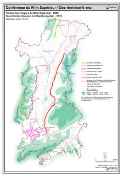
Carte PDF des Routes touristiques du Rhin Supérieur - 2018 PDF Karte der Touristische strassen im Oberrheingebiet - 2018

Limites techniques d'usage

Aucune limite technique d'usage des données renseignée

Informations géographiques

Type de représentation: non renseignée

Etendue géographique:

  • Ouest: 6.25
  • Est: 9.70
  • Sud: 47.02
  • Nord: 49.69

Système de projection: non renseignée

Echelle: non renseignée

Résolution: non renseignée

Documents et ressources

Ouvrir-la-carte-statique-PDF-/-Die-PDF-Karte-offnen
http://www.georhena.eu/sites/default/files/Cartes/07_2018_251.pdf

Mots clefs

routes touristiques touristische strassen 2018 PDF carte Karte
Overview
Synthèse

Mise à jour inconnue
Publié le \{\{'2018-10-08' | formatMeta:'date' \}\}
Thèmes

Contacts

GeoRhena

Dataset schema

JSON Schema

The following JSON object is a standardized description of your dataset's schema. More about JSON schema.

Editer en mode avancé

Exports géographiques

API Cartographiques

WMS
Flux cartographique WMS https://sdi.georhena.eu/geoserver/ows?SERVICE=WMS&
Couche: georhena:Departements_Landkreis_Kanton
WMS
Flux cartographique WMS https://sdi.georhena.eu/geoserver/ows?SERVICE=WMS&
Couche: georhena:ContourCRS_UmrissORK
WMS
Flux cartographique WMS https://sdi.georhena.eu/geoserver/ows?SERVICE=WMS&
Couche: georhena:Rhin_Rhein_ETRS89_2016
WMS
Flux cartographique WMS https://sdi.georhena.eu/geoserver/ows?SERVICE=WMS&
Couche: georhena:Routes_touristiques_ETRS89
WMS
Flux cartographique WMS https://sdi.georhena.eu/geoserver/ows?SERVICE=WMS&
Couche: georhena:ChefsLieux_Hauptorte

API Data4Citizen