Active filters
Aucun filtre actif.
\{\{ ctx.nhits | number \}\}
record
Filtres
Description
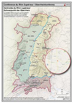
Carte PDF de présentation du centroïde du Rhin supérieur / PDF Karte der Oberrhein Schwerpunkt
Limites techniques d'usage
Aucune limite technique d'usage des données renseignée
Licences et conditions d'utilisation
- GeoRhena
Informations géographiques
Type de représentation: non renseignée
Etendue géographique:
- Ouest: 6.25
- Est: 9.70
- Sud: 47.02
- Nord: 49.69
Système de projection: non renseignée
Echelle: non renseignée
Résolution: non renseignée
Documents et ressources
Mots clefs
centroïde Rhin supérieur PDF carte Karte Oberrhein Schwerpunkt
Synthèse
Mise à jour inconnue
Publié le
\{\{'2020-03-15' | formatMeta:'date' \}\}
Thèmes
Contacts
GeoRhena
Dataset schema
JSON Schema
The following JSON object is a standardized description of your dataset's schema. More about JSON schema.